Distribution of Rainfall in Indian Monsoon
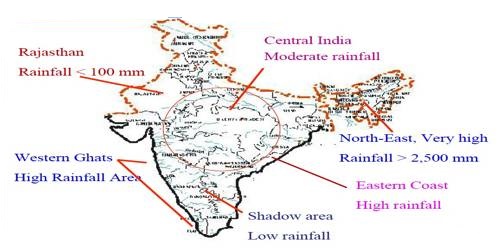
The monsoon of South Asia is among several geographically distributed global monsoons. Despite the observations spread over centuries, the monsoon continues to puzzle the scientists. There is great regional and temporal variation in the distribution of rainfall. Over 80% of the annual rainfall is received in the four rainy months of June to September. The average annual rainfall in India is about 125 cm, but it has great spatial variations (Figure).
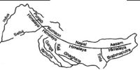
Areas of High Rainfall: The highest rainfall occurs along the west coast, on the Western Ghats, as well as in the sub-Himalayan areas is the northeast and the hills of Meghalaya. Here the rainfall exceeds 200 cm. In some parts of Khasi and Jaintia hills, the rainfall exceeds 1,000 cm. In the Brahmaputra valley and the adjoining hills, the rainfall is less than 200 cm.
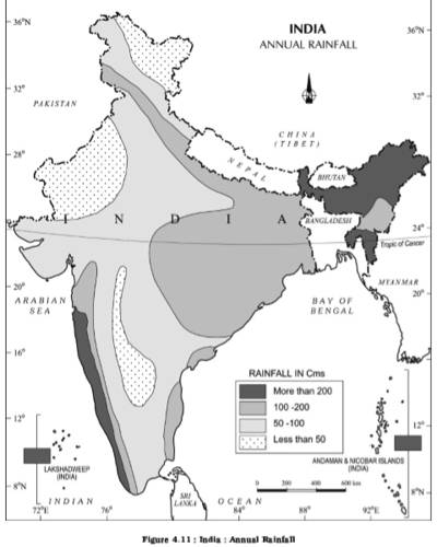
Areas of Medium Rainfall: Rainfall between 100-200 cm is received in the southern parts of Gujarat, cast Tamil Nadu, northeastern Peninsula covering Orissa. Jharkhand, Bihar, eastern Madhya Pradesh, northern Ganga plain along the sub-Himalayas and the Cachar Valley and Manipur.
Areas of Low Rainfall: Western Uttar Pradesh. Delhi, Haryana, Punjab, Jammu and Kashmir, eastern Rajasthan, Gujarat, and Deccan Plateau receive rainfall between 50-100 cm.
Areas of Inadequate Rainfall: Parts of the Peninsula, especially in Andhra Pradesh, Karnataka and Maharashtra. Ladakh and most of western Rajasthan receive rainfall below 50 an.
Snowfall is restricted to the Himalayan region.