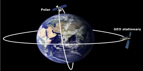
The polar satellites revolve around the Earth in a north-south orbit passing over the poles as the Earth spins about its north-south axis. It is a satellite whose orbit is perpendicular or at right angles to the equator, or in simple words it passes over the north and south poles as it orbits the earth.
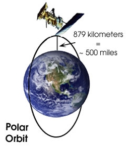
The polar satellites positioned nearly 500 to 800 km above the Earth travels pole to pole in 102 minutes (1 hour 42 minutes). The polar orbit remains fixed in space as the Earth rotates inside the orbit. As a result, most of the earth’s surface crosses the satellite in a polar orbit. As the earth rotates under it while it orbits the earth, Earth presents a different face at every pass, making it possible to map/scan the entire earth’s surface with a Polar satellite over time. As the satellite is in orbit, the Earth is rotating beneath it. As a result, a satellite can observe the entire Earth’s surface (off-nadir) in a time span of 24 hours. Excellent coverage of the Earth is possible with this polar orbit. Polar satellites circle at a much lower altitude than geostationary satellites – at about 850 km. This means that polar satellites can photograph closer up than the high altitude geostationary satellites. Polar-orbiting satellites orbit in a path that closely follows the Earth’s meridian lines, passing over the north and south poles once each revolution.
Applications –
The polar satellites are used for mapping and surveying. They are often used for Earth-mapping, Earth observation, capturing the Earth as time passes from one point, reconnaissance satellites, as well as for some weather satellites. It can also be used as a communication satellite for countries/areas near the poles where Geostationary satellites have no or poor coverage. Polar satellites, therefore, provide more detailed information about violent storms and cloud systems.